It appears we have reached a new historical low flow for this time of year. Current flow at the USGS Point of Rocks gage is 3460 cubic feet per second (cfs) while the lowest flow for today in the 131-year record was 3860 cfs.
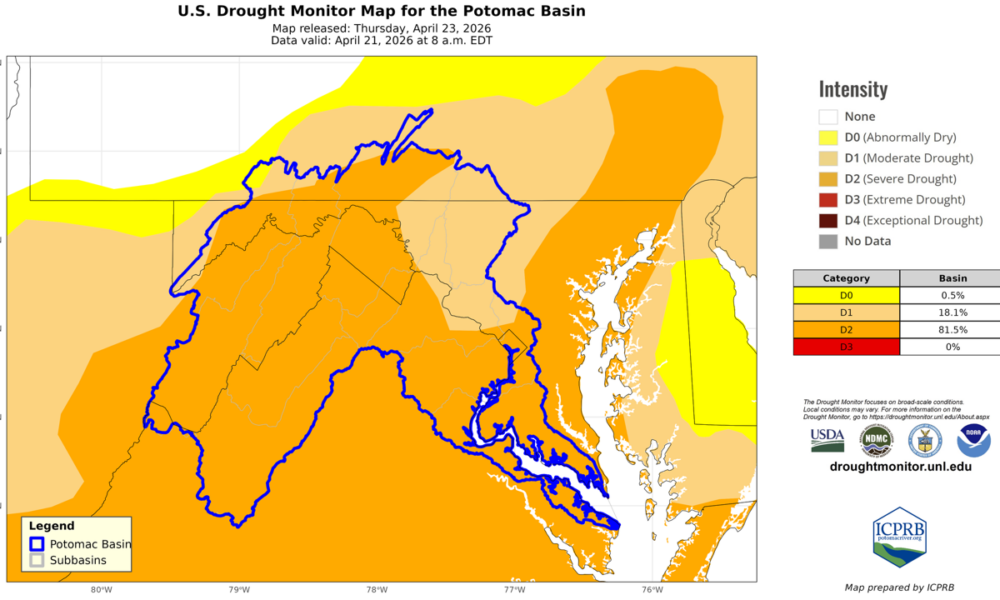
Last Thursday’s U.S. Drought Monitor Map is bright orange, with 82% of the Potomac River watershed in Severe Drought conditions.
The Virginia Department of Environmental Quality (DEQ), has declared a Drought Warning across almost the entire state. This advisory level is intended to spread awareness that the “onset of significant drought event is imminent”.

map courtesy of the Interstate Commission on the Potomac River Basin
Western and central Maryland are in a Drought Watch status, while the Eastern Shore is under Drought Warning. Central Maryland drought status is subject to agreements with subject to agreements with the Metropolitan Washington Council of Governments (MWCOG).
Nine Maryland counties and 24 Virginia localities have received drought disaster declarations from the USDA. Farmers across the basin may be eligible for Farm Service Agency emergency loans due to the drought declarations.
Officials are warning of an increased wildfire risk due to the ongoing dry conditions.
The Interstate Commission on the Potomac River Basin has issued the following public statement:
“We would like to remind everyone to please use water wisely as conditions across the basin are dry. Some examples:
–Take shorter showers
–Only run the laundry or dishwasher with a full load
–Turn the tap off when you aren’t actively using it.”
The U.S. Department of Agriculture (USDA) has designated nine Maryland counties are primary natural disaster areas due to drought conditions.

