


by Michael Nardolilli, Executive Director of the Interstate Commission on the Potomac River Basin
Why are the state boundary lines along the Potomac River so irregular? Why doesn’t the line run neatly down the middle of the river, as it does in many other states? The fascinating story behind the Potomac’s peculiar borders involves colonial land grants, centuries-old legal disputes, and evolving interpretations of land and water rights.
Ownership of the Potomac River was entangled in three conflicting colonial land grants that reflected the lack of knowledge about the watershed by the newly arrived inhabitants.
In the early 1600’s, the Virginia Company received grants for Virginia, Maryland, and parts of Pennsylvania from King James I.
Secondly, in 1632, Lord Baltimore was granted land in what is now Maryland to the Potomac River’s southern bank extending to the river’s “first fountain,” or its source. (This is the basis of Maryland’s claim to the entire Potomac).
Finally, the area between the sources of the Potomac and Rappahannock rivers, known as the Northern Neck, was granted to Lord Fairfax. 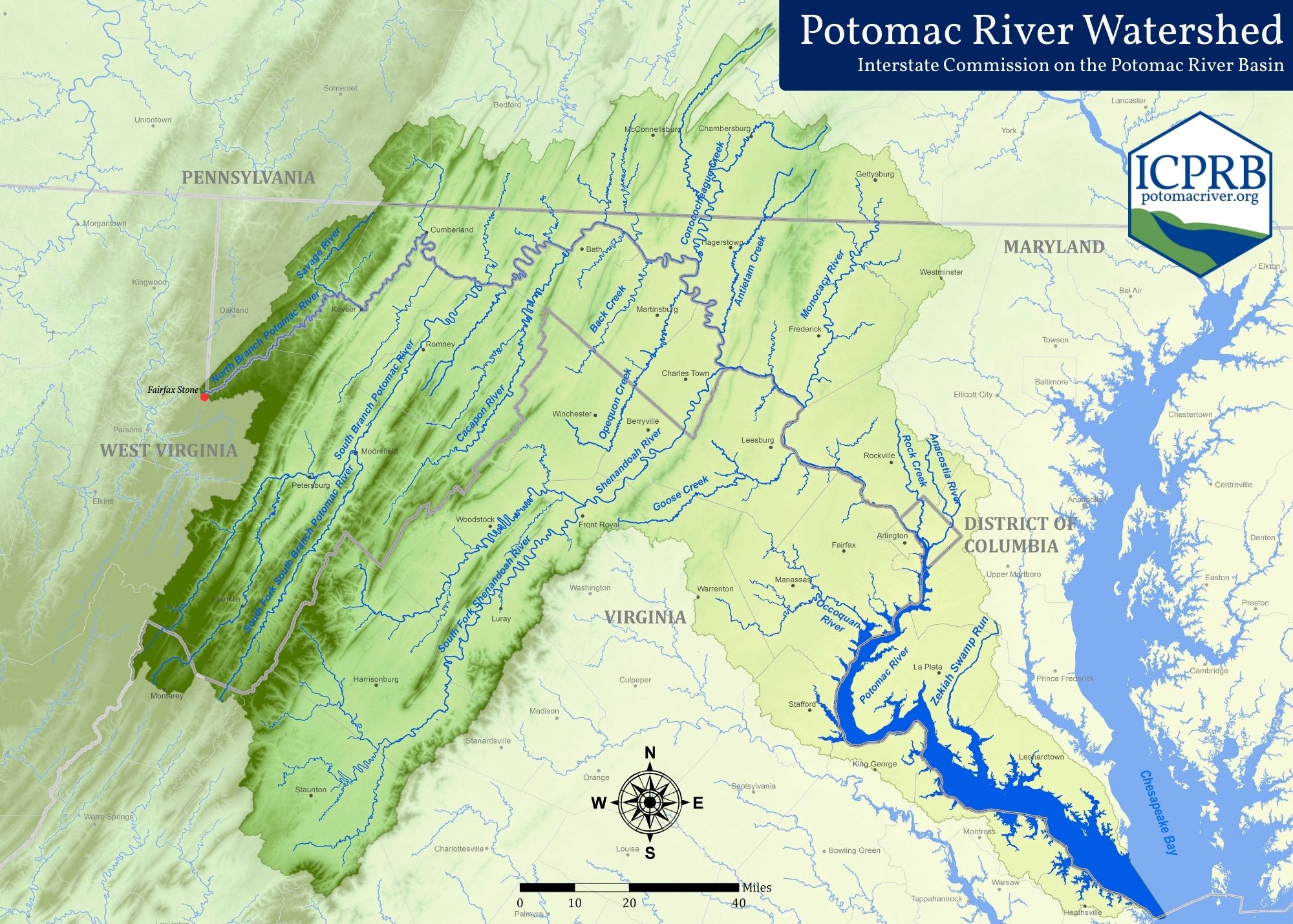
So, the first step was to identify the “first fountain” of the Potomac among the many tributaries in its headwaters. Is the source of the Potomac River what we now know as North Branch Potomac (then known as the Cohaungoruton River)? Perhaps the South Branch? Or is it either the North Fork or South Fork of the Shenandoah?
In 1736, Virginia sent a scouting party up the river to find the source. The surveyors chose the northernmost branch of the river, what we call the North Branch, which just happened to maximize the size of Virginia. Fairfax Stone was designated as the river’s source — and
Boundary marker (credit: ICPRB)
Maryland’s western boundary — setting the stage for centuries of boundary arguments.
In 1776, Virginia’s first Constitution ceded the river to Maryland, but reserved Virginia’s right to “free navigation and use of the river.” Maryland disputed Virginia’s claim, and the two states slapped tariffs on each other’s products that crossed the Potomac. In 1785, George Washington invited conferees from both states to Mount Vernon. There, the Compact of 1785 codified the right to toll-free travel along the Potomac.
Through many court cases, arbitrations, and legislation, the southern bank of the river became recognized as the boundary. The Black-Jenkins Award of 1877 declared the line would run from one headland to the next, not along the shore indentations. Land along the tidal Potomac would be set by the courts. Finally, in 1945, the Congress set the boundary line between DC and Virginia.
The Interstate Commission on the Potomac River is an interstate compact commission established by Congress in 1940. Its mission is to protect and enhance the waters and related resources of the Potomac River basin through science, regional cooperation, and education. Represented by appointed commissioners, the ICPRB includes the District of Columbia, Maryland, Pennsylvania, Virginia, West Virginia, and the federal government.
Find more about the history of the disputes in the Maryland State Archives or in the recent webinar recording, “Who Owns the Potomac” on the Arlington Historical Society’s YouTube channel.