

by Geoff Fox
It’s rained in Washington County and promises of rain are in forecasts, but the Maryland Department of the Environment has issued a drought warning for much of the state, including Washington County.
The announcement came on Thursday, May 14.
The warning is due to persistent rainfall deficits and ongoing dry conditions across the state.
Right now, there currently aren’t statewide water shortages or restrictions. The MDE said three consecutive years of dry weather and recent lower-than-average precipitation amounts means voluntary water conservation by homeowners and businesses is encouraged.
“Every drop counts when it comes to the smart use of water,” said MDE Secretary Serena McIlwain. “We play a role in protecting our water supply, our ecosystems, and our economy.”
McIlwain added that by conserving water today, stricter mandates in the future can be avoided.
Baltimore City has issued voluntary restrictions for areas served by its water system, which also serves areas of Anne Arundel, Baltimore, Carroll, Harford, and Howard counties.
Middletown in Frederick County has prohibited lawn watering and called for voluntary water conservation citing groundwater conditions.
Droughts aren’t unprecedented in the state’s history, as major events occurred in the 1930s and 1960s. A statewide drought emergency with mandatory water use restrictions was declared in 1999.
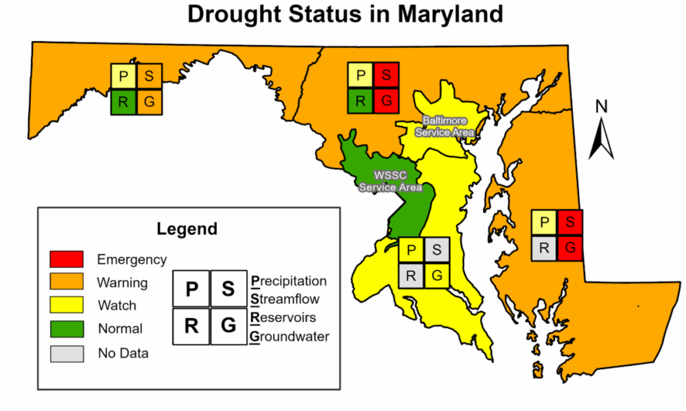
Maryland uses a staged system to provide guidance to the public on water usage.
A drought “watch” is an early-stage alert for the state to monitor conditions more frequently and suggest voluntary conservation.
A warning means worsening conditions and increased coordination between the state and water suppliers.
Western, central, and eastern Maryland are under the drought warning. Southern Maryland is under a watch.
The main cause for the worsening conditions now being seen is a deficit of rainfall over the past several months, which has been about three inches per month on average compared to an average of four inches per month.
According to the National Weather Service charts, from December 2, 2025, to May 15, 2026, Hancock had a reported 9.60 inches of rain recorded in Kirkwood Park.
The accumulating deficit leads to lower than normal groundwater levels and stream flows, causing impacts that recover slowly even with rain.
The MDE said for private wells, voluntary conservation is encouraged statewide, particularly in shallow aquifers.
Farmers should consult with local soil conservation districts and the U.S. Drought Monitor to assess conditions and support water management strategies.
Washington County Office of Emergency Management said simple steps such as limiting unnecessary outdoor watering, checking for leaks, and conserving household water use can help protect local water resources during dry conditions.
The drought has its beginnings in 2024.

The year started out on a rather wet note, with a strong to extreme drought really taking hold that summer and fall, and remained through the winter of 2025, said Fox 5 Meteorologist Mike Thomas in an email to The Hancock News.
“By the spring, though, we did turn a bit of a corner… particularly in May of 2025 when Hagerstown picked up more than double their average monthly rainfall,” he said.
The average rainfall is 3.5 inches and Hagerstown received 7.36 inches.
While Maryland was drought-free for the most part of summer 2025, a dry fall, winter, and following spring brought those drought conditions back.
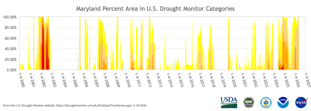
Thomas said as of May 12 of this year, more than 95% of the state is in serve drought.
He said the primary driver is likely the shift from a wetter leaning strong El Niño during the 2023-2024 year to a weaker La Niña/neutral regime over the last two years.
“Historically, these do tend to be drier patterns for the eastern half of the United States, with a weaker subtropical jet stream (which transports moisture from the Gulf region northward) and stronger polar jet stream (which pulls in drier air from Canada) providing less than ideal conditions for a consistent rainfall pattern,” Thomas said.
The 2025 hurricane season came in below expectations, worsening the dryness. The only tropical remnant that impacted the Mid-Atlantic was the remnants of Tropical Storm Chantal in early July.
“It was not a moisture-rich system in our region, and Hagerstown picked up only around a tenth of an inch of rain from the remnant,” Thomas said.
These are pretty normal climate cycles and the region has been in and out of drought many times since the turn of the century.
There have been numerous droughts since 2000, with 2002 being the worst.
This past winter only gave the region one major winter storm, the so-called “snowcrete” storm on January 25, which brought an equivalent 1.99 inches of liquid to Hagerstown, Thomas said.
While it did bring some relief, a drier than average February and March reversed that temporary aid from that storm.
“The remainder of the snow in the winter was generally lighter, and snowfall does not equate to that much liquid when it melts,” Thomas said.
Spring & summer rains
Thomas said rainfall in late spring and summer tends to be much more “convective” as opposed to widespread, all-day soaking rains that aid in drought alleviation.
“We do see thunderstorms and shower chances as we head through the second half of May, but thunderstorm rains tend to be more scattered,” Thomas said. Your house could get one inch of rain while a house a few blocks away gets less, he noted.
A lot of that rainfall from heavy thunderstorms is often lost to runoff, instead of soaking into soils and being filtered naturally in aquifers.
“What we would need in the summer to really aid in drought aid would be either a more sustained shower/thunderstorm pattern, which may become more common towards the late summer as El Niño strengthens and the subtropical jet becomes more active,” he said.
Tropical remnants would also be a big help for more widespread rainfall, though the tropical season is expected to be a “bit more tame” this year due to the impacts of the strengthening El Niño, Thomas said, “but this does not mean a system could not come our way and help us out.”
Around the end of the calendar year, temperatures in the ocean surface along the coasts of Ecuador and northern Peru begin to get warmer.
Due to its appearance around the Christmas season, locals started calling this warming “El Niño,” meaning “The Child.”
Every two to seven years, a much stronger warming appears along the coast of South America, lasting several months.
NOAA’s National Weather Service is predicting El Niño to emerge soon with an 82% chance between May and July and continue through winter 2026-2027 with a 96% chance December 2026 though February 2027.
Thomas said the incoming, “potentially very strong (or ‘super’)” El Niño should be a great help to our region, but most of the southern and western United States as they have also been suffering from the drought conditions.
The more active subtropical jet stream in the Pacific makes moisture heavy, coastal storms more common, most notably during the cooler seasons of fall and winter, Thomas said.
The summer could be a wild card as it would depend on how fast the incoming El Niño strengthens throughout the summer months.
“I don’t expect we will see too much drought relief in the short-term, unfortunately,” Thomas said.